
The structure of this part of the report follows a progression that mirrors the journey of digital transformation in agricultural disaster risk reduction. Section 3.1 on digital technologies transforming agricultural risk management sets the foundational landscape by examining the current challenges facing agriculture and introducing the diverse array of digital tools now available. This section provides readers with a comprehensive understanding of how digital solutions are revolutionizing risk knowledge, monitoring systems and advisory services. By starting with the “what” – the technologies themselves and their immediate applications – the discussion is grounded in concrete examples and proven solutions to establish a solid knowledge base for subsequent sections.
Section 3.2, from early warning to resilient action, demonstrates how these digital tools translate into tangible outcomes for farmers and communities. This section bridges the gap between technology and impact, showing how early-warning systems enable anticipatory actions, how predictive analytics inform decision-making, and how digital innovations build long-term resilience through insurance, social protection and improved disaster preparedness, response and recovery. Finally, Section 3.3 (Mainstreaming digital solutions at scale), addresses the critical question of implementation, examining the enabling conditions, policy frameworks, and human-centred approaches necessary to scale these solutions effectively. This progression from tools to action to scale reflects the real-world pathway of digital transformation, while also providing entry points for various stakeholders – whether they are seeking to understand available technologies, implement specific solutions or develop enabling environments for digital innovation in their contexts.
3.1 Digital technologies transforming agricultural risk management
THE LANDSCAPE OF DIGITAL DISASTER RISK REDUCTION IN AGRICULTURE
Agriculture faces unprecedented challenges from increasingly frequent and severe disasters, fundamentally reshaping how we must approach risk management in the sector. As discussed in Part 2 of the report, the economic effects of localized disasters extend far beyond immediate production losses, cascading through global agrifood systems to affect prices, trade and food security far from the initial impact zone. The vulnerability of agricultural systems is further compounded by their exposure to multiple, often simultaneous hazards that can erase years of agricultural development progress and push entire populations into food insecurity.
The complex and interconnected nature of risk requires advanced analysis for production, interpretation, and communication of actionable information to support decision-making and implementation processes. The lack of timely, localized and actionable information remains a critical gap, especially in regions with limited infrastructure, logistical barriers and conflict situations. Data-driven risk information must be made available and accessible to both farmers and policymakers in formats that are tailored to their needs, ranging from farm-level decision-making to multilevel strategic planning and policy development that support sustainable agriculture.
Digital solutions can serve as a conduit for transferring knowledge to multiple stakeholders and policymakers, empowering them to act. However, for digital solutions to be effective, they must be affordable, accessible, available and capable of overcoming challenges for rural communities, such as the digital divide, unreliable electricity, and limited connectivity and access to the internet and mobile networks.
Farmers also face a range of challenges that include a lack of access to advisories and credits, high cost of inputs, exposure to natural and biological hazards, poor market linkages, limited access to technology and knowledge, and economic burden. These, in turn, affect the ability of farmers to be resilient in the face of disaster risk. Digital tools can help overcome some of these challenges and provide innovative solutions for improving access to advisory services and market linkages, and by facilitating access to credit and loans through traceable means.106,107,108
Facilitated by AI and ML, advanced analytical models have improved our understanding of risk through the integration of multiple types and scales of data (e.g. socioeconomic, farm registration, soil health, crop assessment, land use, metrological, hazard and climate data).4,5 These high-quality data are woven into context-specific digital solutions for building the resilience of farmers and stakeholders, and their widespread use is key to the provision of actionable risk information to farmers and the improvement of agricultural practices.
The growth of new technologies also brings opportunities for extension and advisory services (EAS), bridging the information gap between different value chain actors, contributing to fair trade, market accessibility, and social and financial inclusion, and enhancing accessibility, delivery, transparency, scope, and impacts of information and services.109 Key elements of digital technologies can provide hyperlocal and personalized agriculture EAS in terms of agrometeorological advisories, education, access to microfinance and insurance services, market prices, supply chain management, and pest and disease advisories, which are frequently bundled together by service providers.110
Location-specific, real-time and context- sensitive EAS help farmers tailor their agronomic practices based on weather patterns and market demands. The possibility to culturally and linguistically customize information ensures targeted messages that bridge key socioeconomic gaps in rural communities, and the use of simultaneous multichannel delivery of EAS through radio, television, mobile phone and the internet can help overcome accessibility challenges, including literacy.
Before examining how digital tools enable proactive responses to agricultural disasters, we must first understand what these technologies are and how they function. This section surveys the digital innovations currently reshaping agricultural risk management—from satellite monitoring systems and data platforms to mobile advisory services and predictive analytics. Each subsection demonstrates specific technological capabilities through working examples, building from basic data collection tools to more sophisticated analytical systems. This progressive exploration of existing technologies and their applications prepares the ground for Section 3.2’s examination of how these same tools drive anticipatory action and long-term resilience building.
DIGITAL TOOLS FOR RISK KNOWLEDGE AND MONITORING
Digital solutions enhance data collection, analysis and granularity. Gaining a better understanding of disaster risks and their trends depends on accessing granular, detailed data that provide insights into the multifaceted dimensions of hazards, such as likelihood, intensity, timing and effects. This process allows for the identification of risk patterns or trends, which inform planning and decision-making for preparedness and anticipatory actions. Given the nature of agricultural subsectors and their regional and subregional variability, understanding the current situation and projecting long-term change can only be achieved through the use of interoperable data and the application of innovative digital solutions.
Information systems and data sharing platforms
Effective, consistent and timely risk communication depends on data sharing to enhance knowledge for planning, policymaking and decision-making. Increasing data availability and creating tools that assist users in linking hazard, exposure, vulnerability, and coping capacity are key to improving both disaster risk knowledge and access to stakeholders.
Prominent data/information sharing platforms include FAO’s GIEWS. It provides regular and up-to-date data on factors impacting global food supply and demand conditions, in turn aiding national and regional monitoring systems. This information includes near-real-time earth observation data on drought conditions through the Agricultural Stress Index (ASI) and weekly and monthly food price data across more than 120 countries uploaded onto the Food Price Monitoring and Analysis (FPMA) Tool. This data is also synthesized in outlook reports, aimed at triggering anticipatory actions and providing evidence for policy decisions. Likewise, the Kenya Agriculture Data Sharing Platform shares and integrates data on early warning, weather, soil, pest and diseases. The Vulnerability Analysis and Mapping Data Visualization (VAM DataViz) platform 111 of the World Food Programme (WFP) provides similar data to the HungerMap Live.112
Global organizations such as the UNDRR work with stakeholders to provide more actionable risk information to inform decision-making through standardized risk data.113 The DELTA Resilience system standardizes data collection and analysis on disaster impact across sectors and replaces the Desinventar database. It ensures consistency and comparability across regions by improving data integration and analysis and expanding the dimensions of monitored impacts to capture non-economic dimensions such as cultural losses, health and well-being food security, biodiversity and ecosystem health.114 DELTA Resilience also tracks the impacts of climate-induced slow-onset events and processes that have uncertain onset or end dates but cause significant losses and damages.115
By incorporating data standards, definitions and taxonomies to create a harmonized database of disaster impact, the DELTA Resilience demonstrates the power of data interpolation and supports cross-border data comparability. By understanding how hazards interact with vulnerable communities, the database aims to advance disaster risk knowledge for different social groups, places and sectors. Converting data and information into insights for better multilevel decisions and action helps strengthen DRR. Better disaggregated data from cross-cutting sectors, such as agriculture, would improve impact analysis by comparing baseline conditions with observed effects and informing more sophisticated analysis.
Remote sensing and advanced risk assessment
Remote sensing can be very useful for disaster risk management (DRM), as it allows for quick data collection before and after disasters. Remote sensing includes satellite imagery, aerial images, and data from ground-based sensors like radar and laser scanning. Additionally, satellite-based observations provide real-time data for EWS, crop production models and disaster impact assessments. Instruments like MODIS, ASTER, Landsat, and Sentinel can be used to compile hazard maps and assess disaster impacts. The use of unmanned aerial vehicles (UAVs) and ground-based sensors is less common but offers high-resolution data for detailed assessments. GIS is essential for generating maps, analysing risk indicators, and visualizing data, often integrating remote sensing and Global Positioning System (GPS) data.
Advances in technology, including AI, ML, IoT and crowdsourcing, have enhanced geospatial approaches to DRM, enabling more precise and timely assessments, with smartphone applications providing real-time information and facilitating community reporting. Cloud computing and AI and ML tools employ cutting-edge DRM technologies. Cloud computing enables faster and more efficient processing and analysis of vast datasets and is arguably one of the most significant advances for disaster risk knowledge. However, the required computing power, by conventional means of desktop computing, may often be difficult to access for many stakeholders.
AI and ML have further enhanced the ability to forecast hazards and improve DRM. For example, Google’s GraphCast uses AI models to provide faster, more accurate global weather forecasts.116 Similarly, NVIDIA’s Fourier Forecasting Neural Network offers an advanced global weather prediction model, delivering weeklong forecasts in less than two seconds, far quicker than existing methods like the European Centre for Medium-Range Weather Forecasts (ECMWF) Integrated Forecasting System (IFS), while maintaining or improving accuracy.117 Additionally, data platforms such as digital land cadastres provide accurate geospatial data on land ownership, use and characteristics. This data supports risk assessment, planning, and response efforts by identifying vulnerable areas and informing land use decisions. By integrating cadastral data with hazard maps and emerging technologies like AI and ML, these platforms can assist in zoning regulations, the development of disaster-resilient infrastructure and evidence-based policymaking.
Climate risk assessment tools
There are several challenges in translating disaster risk data into knowledge and actionable information, including limited specialist skills, the time needed for location-specific analysis and the difficulty in communicating with diverse stakeholders using a common language. To overcome these challenges, new information platforms using cloud computing and GIS have been developed. For example, OpenForis is a suite of tools, including EarthMaps and Earth Engine, developed as a collaboration between FAO and Google.118 These tools successfully support situational analysis and make results accessible, hence providing a more concerted approach for DRR.
FAO’s Hand-in-Hand (HiH) initiative provides integrated analyses via advanced geospatial modelling and analytics to identify key areas for raising incomes, improving nutrition and building resilience, such as developing value chains, improving water management, and introducing digital services and precision agriculture.119 HiH offers an increased speed of data sharing and analytical tools, including analytical layers for elevating risk knowledge and setup cost reduction. One example of these tools is the CRTB, which grants access to high-quality climate data to be layered onto socioeconomic, food security and agricultural data.120
The CRTB is an open-access resource hosted on FAO’s Agro-informatics Geospatial Platform that harnesses data from FAO and other leading public data providers across the United Nations, NGOs, academia, the private sector and space agencies. This dataset equips stakeholders and policymakers with up-to-date information to enhance climate resilience in agricultural projects, policies and decision-making. It also includes capacity development efforts (e.g. training workshops and technical support) for users to effectively interpret data and apply the tool in a real context. The CRTB has benefited from financial and technological support provided by FAO at zero cost, and contributes to the implementation of FAO’s Strategy on Climate Change by informing evidence-based interventions and decision-making using updated climate science and data in over 200 projects.121
The CRTB aims at addressing risks effectively by visualizing high-risk areas and identifying key weaknesses in climate risk management across the project cycle. It integrates observed and projected climate hazards with their impacts on agricultural systems and communities, providing tailored recommendations for agricultural transformation and adaptive capacities of farmers and rural communities through climate-resilient practices and technologies.122
The CRTB is designed for early-stage climate risk screening, making it valuable to project design teams and policymakers. However, users can also access geospatial data for each climate risk component and tailor their risk analysis by overlaying climatic, geographic, social and economic factors. The tool can be further customized for local, regional and national purposes, integrating local high-resolution and specific datasets. The platform’s flexibility enables integration with other FAO tools.
The CRTB combines a large number of high-resolution geospatial data from climate, socioeconomic and environmental datasets, provided by, for example, the World Bank, the UNDP, the Intergovernmental Panel on Climate Change (IPCC) Atlas, FAO’s Global Information System on Water and Agriculture (AQUASTAT) and FAOSTAT, the United Nations Environment Programme World Conservation Monitoring Centre (UNEP-WCMC), the National Aeronautics and Space Administration/Consultative Group on International Agricultural Research (NASA/CGIAR), the Heidelberg Institute for International Conflict Research (HIIK), the Internal Displacement Monitoring Centre (IDMC), and the Global Data Lab, into a single, user-friendly platform. By doing so, the CRTB ensures a more holistic and accessible analysis of climate risks and reduces the technical barriers for users with limited GIS expertise, while also enhancing the capacity of project developers, policymakers and climate funds to design tailored interventions. The CRTB integrates these data with a comprehensive framework based on the IPCC’s latest climate risk definition and enables faster, more accurate and cost-efficient climate resilience programming.123
FIGURE 21 El Niño Risk Index, Zimbabwe
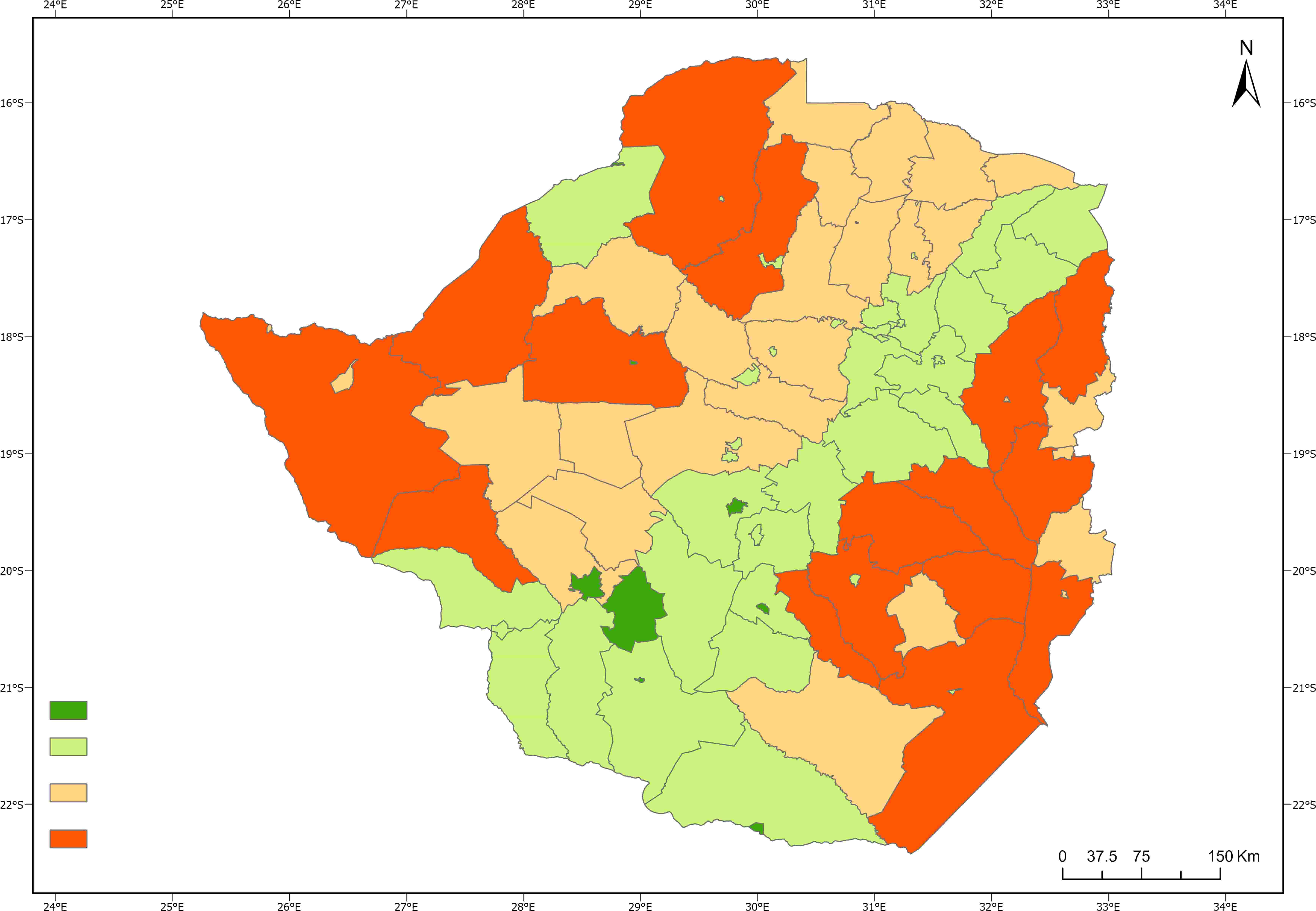
Source: Authors’ own elaboration based on DIEM app and FAO. n.d. DIEM event viewer. [Accessed on 1 August 2025]. https://data-in-emergencies.fao.org/pages/diem_eve. Licence: CC-BY-4.0.
Risk mapping and early impact assessment
The ability to understand geographical differences in exposure is another key element for DRR. Risk mapping is highly beneficial at a regional or national level, especially in anticipating and preparing for specific hazards. Risk maps create an objective, data-driven perspective that can provide forecasts and warnings for context- or sector-specific challenges to be translated into intervention strategies.124 Multihazard risk mapping is an ongoing area of research, and inevitably seeks opportunities for harnessing ML.125 The Data in Emergencies (DIEM) initiative, ahead of the 2023 El Niño and 2024–2025 La Niña is a recent example of risk mapping in the Southern African Development Community (SADC) region.
El Niño is associated with heightened risk to agriculture and significant impacts. Assessing the impacts of this transnational meteorological hazard requires considerable layers of data at different stages of the hazard, as well as historical records that feed into time-sensitive decision-making. FAO’s DIEM and GIEWS have been able to support and collaborate with SADC member states in leveraging new digital solutions to address the challenges of reliable, timely, accurate, and granular information ahead of and during the 2023/24 El Niño agricultural season.
The process required three stages. First, a clear understanding of El Niño-related risk components with negative agricultural livelihood outcomes: hazard (historical probability of having El Niño-led rainfall anomalies), exposure (maize main seasonality aspects from start of season to end of season), and vulnerability (underlying conditions that could exacerbate the impact of rainfall anomalies on crop failure and livelihoods). By doing this, risk “hotspots” were highlighted, permitting prepositioning of resources for further impact assessment at the end of the agricultural season. Second, data on food security, livelihoods and agricultural monitoring were gathered during the cultivation and planting period to provide timely updates on the effects of the disaster. Areas at the highest risk were oversampled to increase the precision of the data. Data was collected with computer-assisted telephone interviews (CATI), a technology that can improve data collection in certain contexts. Third, the measure of hazard impact must be conducted on time and at a sufficient granularity to determine the scale of the required support and the most efficient use of response resources. During this process, a layering of data from multiple sources (household surveys, damage and loss assessments, remote sensing, key informant interviews for seed security), leveraging different levels of digital technology, results in multidimensional views of the impact of El Niño.
DIGITAL ADVISORY AND EXTENSION SERVICES
Digital innovations can improve how agricultural knowledge and advisory services reach farmers, transforming conventional extension systems into dynamic, responsive and personalized support networks. Such digital advisory services bridge critical information gaps and provide farmers with timely, context-specific guidance that enhances their decision-making capabilities and resilience to various risks.
Soil health advisory systems
Digital technologies have significantly changed soil health assessment exercises and related information. Healthy soils form the foundation of agricultural growth, healthy and nutritious food production, and essential ecosystem services.126 Improving soil health is key to combatting climate change through carbon sequestration and customization.127 Roughly 95 percent of the food supply relies on healthy soil – maintaining soil structure, improving water retention and increasing carbon sequestration. Farmers lack easy access to soil health assessments and the identification of nutrient balance. This leads to the progressive decline of soil quality, affecting productivity and the environment.
Digital technologies move away from simple soil sampling and laboratory testing and allow for large-scale soil mapping with the support of remote sensing and ML. Soil reflectance spectroscopy, both in laboratories and via satellite and unmanned aerial systems (UASs), allows visualizing soil characteristics (e.g. mineralogy, organic matter, texture and colour) within the visible near infrared (vis-NIR) spectrum (400 to 2 500 nm). Mid-infrared (MIR) spectra have also proven highly effective in predicting various physical, chemical and biological attributes of soil.128 This vast amount of generated data represents a significant opportunity for farmers to benefit from soil health advisory services but also poses a challenge of how these data can be translated into actionable information.
The SoilFER project aims to match soil health data with fertilizer recommendations.129 SoilFER uses extensive geospatial data and information on soil management, crop selection, and input practices to promote the efficient use of fertilizers, sustainable farming practices, and the selection of major and opportunity crops to positively impact soil health and the livelihoods and resilience of farmers. The SoilFER global geospatial platform (see FIGURE 22) was launched at the Sixteenth meeting of the Conference of Parties to the Convention on Biological Diversity (COP 16) in Riyadh in December 2024, and can be employed to assess the potential for growing different crops for a specific land area, the interaction between soil types, irrigation practices, climate and soil characteristics, while evaluating scenarios (also across countries) of different levels of input management. Similarly, practitioners and extension services can assess and compare the gap between obtained yield and attainable yield with other areas, crops and management options (FIGURE 23).
FIGURE 22 SoilFER GEOSPATIAL PLATFORM
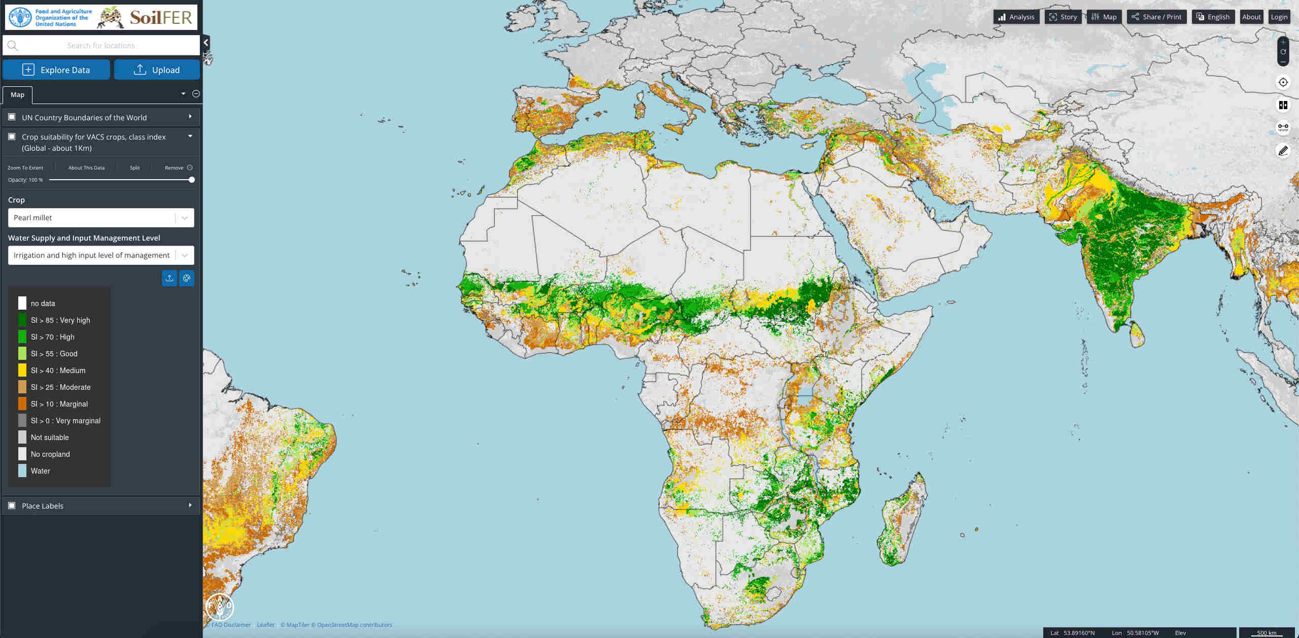
Source: Author’s own elaboration based on FAO. 2025. SoilFER geospatial platform. In: FAO. [Cited 1 August 2025]. https://data.apps.fao.org/soilfer/?lang=en
FIGURE 23 SoilFER APP FOR CROP SUITABILITY – SOIL TYPE SELECTION
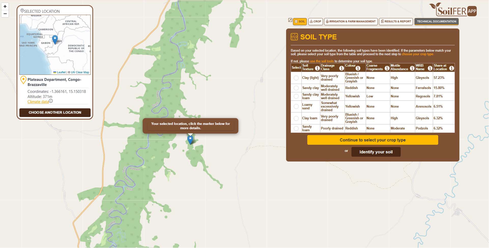
Source: Author’s own elaboration based on FAO. 2025. SoilFER geospatial platform. https://data.apps.fao.org/soilfer/?lang=en
Other solutions also offer similar innovative approaches. Digital soil health kits help communities check their soil health and access tailored agronomic advisories based on their type of soil and crops.130 For large-scale farming, solutions such as SoilOptix help optimizing inputs and maximizing yields by collecting and analysing field data.131 Innovative Solutions for Decision Agriculture (iSDA) built the first field-level soil map for Africa, with more than 20 soil properties at a resolution of 30 metres.132 This open-source platform supports advisory and analytical functions and enables informed decision-making through the AI-based “virtual agronomist”, which communicates and delivers tailored, data-driven advice via a call-centre modality. 133
Water management advisory services
Worldwide, agriculture accounts for 70 percent of freshwater withdrawals, with growing pressure on water supplies. Hence, sustainable water resources management remains critical in agriculture.134 Drought and floods lead to crop failure, soil degradation and food insecurity. Digital technologies and innovations, such as real-time satellite data, help countries and communities monitor and sustainably manage their use of groundwater, such as the Managing Aquifer Recharge and Sustaining Groundwater Use through Village-level Intervention (MARVI) project in India.135 Global efforts such as Geo Aqua Watch improve the coordination, delivery and utilization of water quality information using satellites.136 In Kenya, the Water Management as a Service Platform (WMaaSP) decision-making tool uses sensors to provide supply and demand patterns based on groundwater extraction data.137
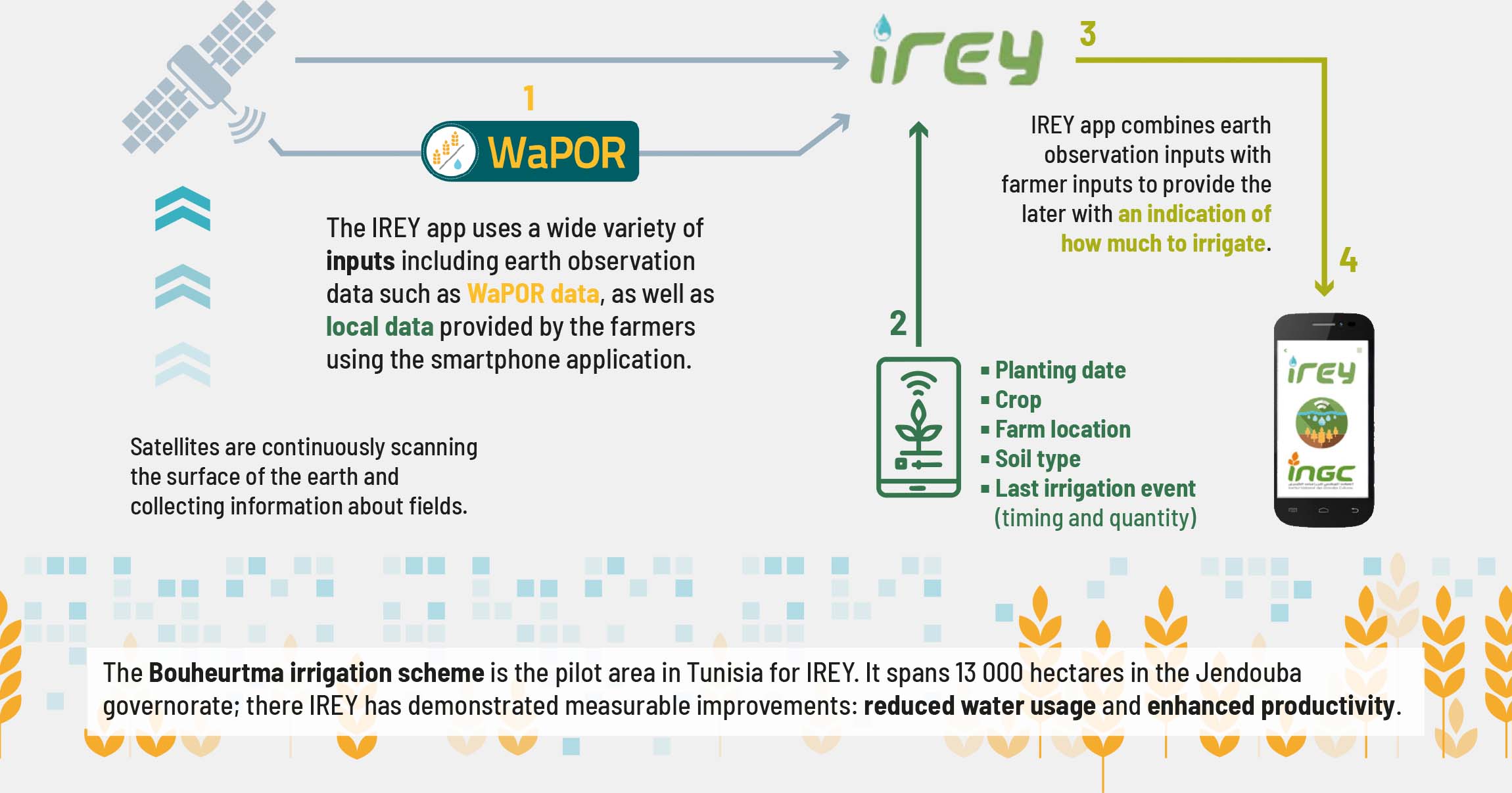
FAO’s WaPOR project provides this data and is ultimately improving water management.138 For example, irrigation scheduling apps on smartphones, like the Irrigation Reference to Enhance Yield (IREY) app in Tunisia, translate and combine satellite data with local insights to provide actionable information to farmers (FIGURE 25). IREY uses a wide variety of inputs, including earth observation data from WaPOR and data provided by the farmers through the app for tailored information on the development of wheat crops. It optimizes irrigation practices towards more sustainable water use and improved crop yields
FIGURE 24 SoilFER APP FOR CROP SUITABILITY – RESULTS AND REPORT
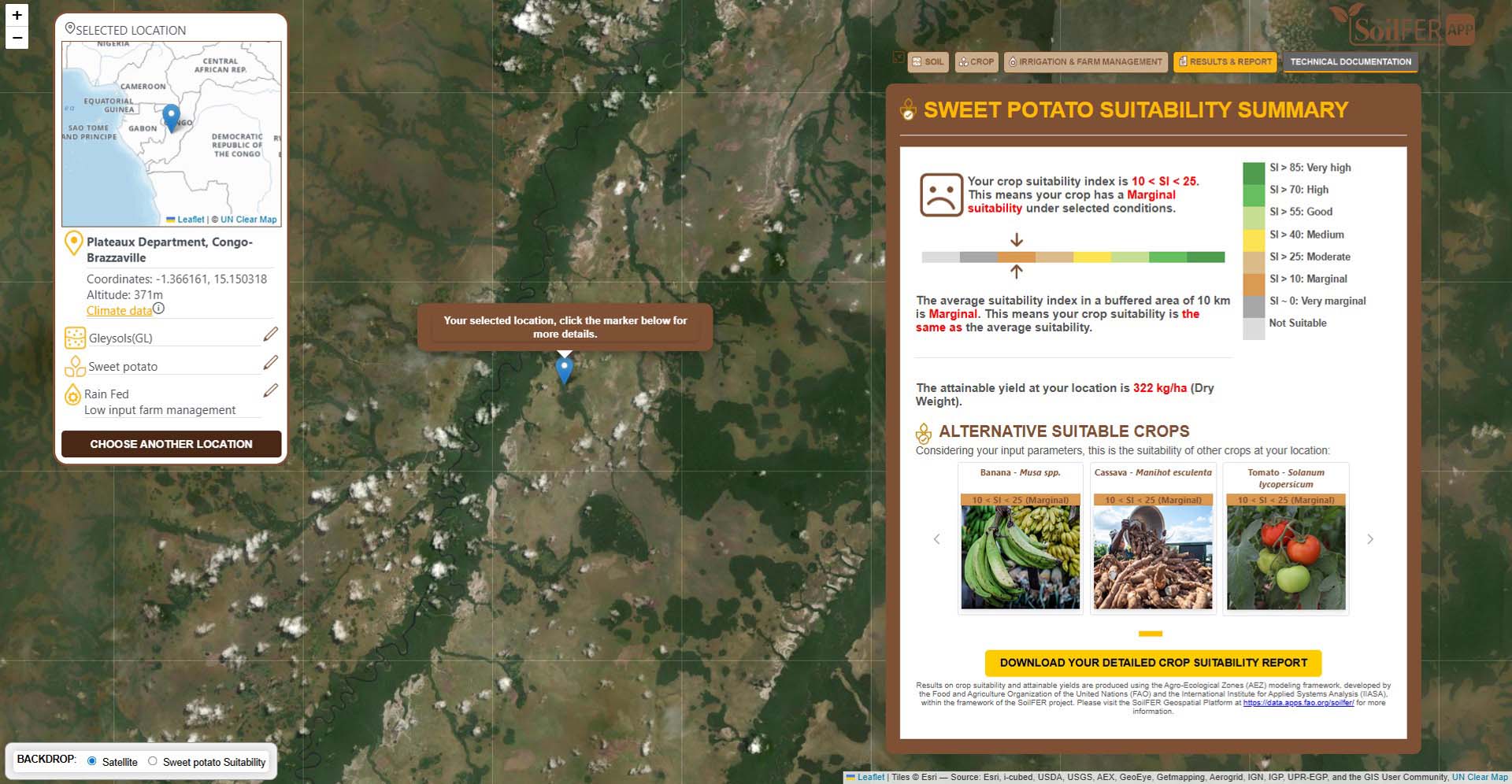
Source: Author’s own elaboration based on FAO. 2025. SoilFER geospatial platform. In: FAO. [Cited 1 August 2025]. https://data.apps.fao.org/soilfer/?lang=en
FIGURE 25 Information flows from the fields to farmer smartphones
Agrometeorological advisory services
Agrometeorological (agromet) advisory services help farmers make informed decisions on water and fertilizer management, pest and disease control, sowing and harvesting schedules, and weather forecasting. Agromet advisories are driven by data availability and quality, as well as by the capacity to analyse data. They have positive impacts on agriculture only when the context- and location-specific information reaches the users (e.g. farmers) with the support of mobile technologies, in a timely manner and in the right language.139 Agromet advisories combining weather forecasting and climate and crop modelling enable communities to enhance their climate-informed decision-making. By focusing on context-specific needs and comprehensible risk information, agromet advisories can adopt a people-centred approach for climate services through the incorporation of feedback mechanisms between scientists, governments, private institutions and farmers.140
In India and West Africa, agromet advisories provide economic benefits to farmers. In Haryana, India, farmers reduced input costs by approximately USD 29.65 per hectare for wheat and USD 44.48 per hectare for paddy rice.141 In Raichur and Bidar districts, the yields of pigeon pea, soybean and pearl millet increased by 233, 98 and 318 kg/ha, respectively, when agromet advisories were utilized.142 In the entire study area, the value addition for these three crops in a single season is of USD 9.66 million. Similarly, in Karnataka and Andhra Pradesh, agromet advisories increased farmers’ profit from 12 to 33 percent.143
In Niger and Mali, agromet advisories improved farmers’ incomes by USD 40 per hectare at the start of the season, USD 24 per hectare during the cropping season and USD 10 per hectare by the end of the season.144 In Southwestern Niger, agromet advisories increased farmers’ incomes by USD 116 on average for a 3-hectare farmland.145 In Burkina Faso, agromet advisories reduced production costs by 40 percent and increased income by 41 percent.146 Agromet advisories can also have environmental impacts, like in the Burkina Faso study, where agromet advisories reduced fertilizer use by 50 percent.
Many other existing platforms cater to large-scale producers, supported by corporate entities that embrace full digital integration.147 However, these sophisticated tools often come with costs that farmers cannot sustain. Emerging transformative solutions, such as AI-driven chatbots and decision-support tools, can provide real-time and context-specific advice across the value chain, empowering farmers and vulnerable groups with actionable insights.
TABLE 2 SUMMARY OF IMPACTS OF AGROMET ADVISORY SERVICES*

Source: Authors’ own elaboration using referenced literature: i Manjunath, K.V., Maiti, S., Garai, S., Reddy, D.A.K., Sahani, S., Panja, A. & Jha, S.K. 2024. Impact of climate services on the operational decision and economic outcome of wheat (Triticum aestivum) and rice (Oryza sativa) cultivation in Haryana. The Indian Journal of Agricultural Sciences, 94(3–1): 116–123. https://doi.org/10.56093/ijas.v94i3.148633; ii Dupdal, R., Dhakar, R., Rao, C.A.R., Samuel, J., Raju, B.M.K., Kumar, P.V. & Rao, V.U.M. 2021. Farmers’ perception and economic impact assessment of agromet advisory services in rainfed regions of Karnataka and Andhra Pradesh. Journal of Agrometeorology, 22(3): 258–265. https://doi.org/10.54386/jam.v22i3.187; iii Bizo, I.M., Traore, B., Sidibé, A. & Soulé, M. 2024. Effectiveness of climate information services: An evaluation of the accuracy and socio-economic benefits for smallholder farmers in Niger and Mali. Frontiers in Climate, 6: 1345888. https://doi.org/10.3389/fclim.2024.1345888; iv Seydou, T.H., Agali, A., Aissatou, S., Seydou, T.B., Issaka, L. & Ibrahim, B.M. 2023. Evaluation of the impact of seasonal agroclimatic information used for early warning and farmer communities’ vulnerability reduction in southwestern Niger. Climate, 11(2): 31. https://doi.org/10.3390/cli11020031; and v Tarchiani, V., Coulibaly, H., Baki, G., Sia, C., Burrone, S., Nikiema, P.M., Migraine, J.-B. & Camacho, J. 2021. Access, uptake, use and impacts of agrometeorological services in Sahelian rural areas: The case of Burkina Faso. Agronomy, 11(12): 2431. https://doi.org/10.3390/agronomy11122431
Integrated digital advisory platforms
FAO’s SEED Hub in Sri Lanka provides an example of a transformative digital intervention.148 Developed by the Agrifood Economics and Policy Division (ESA), the Digital FAO and Agro-Informatics Division (CSI) in collaboration with the Ministry of Agriculture, the Department of Meteorology, and the Hector Kobbekaduwa Agrarian Research and Training Institute of Sri Lanka, the SEED Hub app delivers free-of-charge, geo-localized, timely and integrated advisory services. The app empowers farmers with critical information such as weather forecasts, crop management practices, market prices, agrometeorological and agromarket advice. During the 2023/2024 Maha season pilot, farmers using the SEED Hub app experienced significant gains compared to their peers without access to the app. On average, they achieved a 26 per cent increase in rice productivity, a 48 per cent boost in rice sales, and received 33 per cent higher market prices. Additionally, they diversified their production with an average of 0.73 more crops per farmer. Successes were also observed at the village level, as most farmers were accessing and sharing information even when only a few farmers were directly receiving information on the app. This collective knowledge sharing is an important reference for other digital advisory services in contexts with low digital literacy.
Strengthening farmers’ collective resilience offers a powerful opportunity for impactful, integrated, and holistic interventions. While notable progress has been made in agricultural and marketing decision-making, the lack of observed improvements in household food security underscores the complex link between agrifood systems and household consumption – highlighting critical areas where further coordinated support is needed. Farmers also need access to financial markets – including affordable credits and insurance – to manage risks and invest in productivity enhancing inputs. Furthermore, systemic infrastructure gaps – such as inadequate post-harvest storage, poor road networks and limited access to markets – can hinder their ability to fully benefit from improved access to information. To fully unleash the potential of digital decision tools like the SEED Hub, they need to be mainstreamed into existing agricultural systems as part of a more comprehensive approach, integrating digital extension services with complementary agricultural interventions and DRR plans and strategies.
Other successful examples include a community video-based extension by Digital Green to encourage farmers to improve agronomic and livestock practices149 and “Uliza”, an extension that combines radio, mobile phones and interactive voice response to enable listeners to communicate and exchange information in local languages with their radio station quickly, easily and free of charge.150 These have proven to be effective in leveraging community volunteers and incorporating digital solutions. Kuza is another example that provides bundled solutions, such as agricultural advisories, access to quality input and credits to transform rural youth into agripreneurs.151 A comprehensive list of examples can be found in FAO’s AgriTech Observatory152 and the Digital AgriHub Dashboard.153
While these initiatives have achieved notable success, their impact can be further amplified by addressing key opportunities – such as enhancing digital literacy among farmers, strengthening human capital, and the increasing investment in rural infrastructure.154,155 Despite these advances, challenges such as regulatory barriers, costs and integration into existing DRR frameworks remain, highlighting the need for continued collaboration and strategic investment.


